

Estes Park Wall Map
$14.99
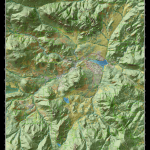
This beautiful Essence of Estes Park Map captures the essence of the Estes Park area and provides a wealth of information for visitors and residents. The map was designed as cartographic art to be viewed from two perspectives. From a distance the map illustrates the topography, vegetation, rivers, lakes and major roads of the valley. When viewed closely the map reveals many more details such trails, local streets, parks, public lands, and other recreation resources.
48 in stock
Description
Full Size: 38 x 48
Format: Flat – Rolled – Wrapped
Full Color: 1 Sided
Paper: 50# Satin
Wall maps are packaged in high quality tubes to protect them during shipping. The US Postal Service charges a premium price to ship the tubes.
Full Map Description
This beautiful Essence of Estes Park Map captures the essence of the Estes Park area and provides a wealth of information for visitors and residents. The map was designed as cartographic art to be viewed from two perspectives. From a distance the map illustrates the topography, vegetation, rivers, lakes and major roads of the valley. When viewed closely the map reveals many more details such trails, local streets, parks, public lands, and other recreation resources. By designing the map to be viewed at two perspectives, the map does not become to “busy” when viewed from a distance. One of the most useful aspects of the map is known as hillshade. Hillshade adds shadows to the map which accentuates the topography and makes it look three dimensional. This map was designed as a large wall map to provide a great amount of detail. The map is 38 inches wide by 48 inches tall and printed at a scale of approximately 1 inch equals 0.25 miles (1:14,000).
Estes Park is the gateway to Rocky Mountain National Park and Roosevelt National Forest. The Estes valley is home to the best wildlife watching opportunities in Colorado and the western United States. There’s an impressive diversity and length of trails of all kinds. Golf Courses, parks and conservation lands (both public and private) are found throughout the valley. The area has a long and rich history with many interesting places to visit. All of these qualities have led to the development of diverse and high-quality lodging, dining, shopping and recreation services. The map legend includes: homes/buildings, springs, historic sites, horse stables, RV campgrounds, urban parks, scenic overlooks, trailheads, visitor centers, classified trails, classified roads, gates, classified streams, 40 ft. & 200 ft. contour lines, and habitats including wetland/riparian, mixed conifer with aspen, conifer, aspen/ cottonwood, grassland, shrub/ juniper, developed/ lawn, rock outcrops, and lakes.
Download the map on Avenza!
Additional information
| Weight | 18 oz |
|---|---|
| Dimensions | 3 × 38 in |
| Paper | 50# Satin |
| Format | Flat – Rolled – Wrapped |
| Package | 1 |
Related products
-

Buena Vista & Salida Trails Folded Map
$14.99 Add to cart -
Rampart Range Trails Folded Map
$11.99 Add to cart -
Essence of Estes Park Map Digital – Draft
$14.99 Add to cart -
Woodland Park Hike & Bike Wall Map
$14.99 Add to cart -
Alamo Lake Off-Road Guide
$6.99 Add to cart -
Divide & Woodland Park Trails Map – 2024 Edition
$15.99 Add to cart


Reviews
There are no reviews yet.