
Buena Vista & Salida Trails Folded Map
$14.99
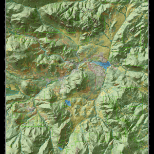
Buena Vista and Salida are located in Chaffee County Colorado with the Continental Divide to the west, Arkansas River Valley in the center and Aspen Ridge in the east. The Salida Ranger District covers most of the map and is located in San Isabel National Forest. The map also overlaps with Pike, Rio Grande and Gunnison National Forests.
2835 in stock
Description
Full Size: 26.5 x 26.5 in
Folded Size: 5.5 x 6.75
Full Color: 2 Sided
Paper: Water/Tear Proof Plastic Paper
Full Map Description
Buena Vista and Salida are located in Chaffee County Colorado with the Continental Divide to the west, Arkansas River Valley in the center and Aspen Ridge in the east. The Salida Ranger District covers most of the map and is located in San Isabel National Forest. The map also overlaps with Pike, Rio Grande and Gunnison National Forests. The Bureau od Land Management (BLM) and Colorado Parks & Wildlife provide other public lands and recreation opportunities in the area. The map features Collegiate Peaks Wilderness, Buffalo Peaks Wilderness, Antero Reservoir State wildlife Area, Arkansas Headwaters State Recreation Area, Browns Canyon National Monument, and Sangre de Cristo Wilderness. Communities include Granite, Buena Vista, Johnson Village, Nathrop, Saint Elmo, Whitepine, Salida, Wellsville, Poncha Pass, and Sargents. Elevations range from 7,059 feet above sea level in the Arkansas River Valley to over 14,000 feet in the Rocky Mountains. Indeed, Chaffee County has the highest concentration of 14ers of any county in Colorado. Additionally, there are over 833,000 acres of public lands illustrated on the map of which the vast majority can be explored, hunted and fished.
Roads and trails are clearly classified based on the types of recreational uses allowed on them. The map illustrates the following road and trail classifications: 435 miles of scenic highways & major roads, 302 miles of scenic gravel and local roads, 965 miles of roads open to all vehicles (including OHVs), 46 miles of 50 inch OHV trail, 163 miles of single-track motorcycle trail, 307 miles of bike & hike trail, and 259 miles of hiking/equestrian trail. Combined, there are over 2,470 miles of scenic roads and trails on the map! Featured trails on the map include Triad Ridge single-track motorcycle trail, Four Mile OHV trails, Continental Divide National Scenic Trail, Colorado Trail, Midland mountain bike trails, Arkansas River rafting/kayaking trail, Carnage Canyon rock crawling trail, Collegiate Peaks Scenic Byway, Arkansas Hills/Salida Mountain trails, Rainbow trail, and Monarch Crest trail. Also illustrated are many other recreation features such as campgrounds, dispersed camping, trailheads, parking, hot springs, Monarch Ski Area, historic sites, mountain peaks & passes, lakes, rivers & streams, springs, waterfalls, public and private lands.
Land management agency maps should be used with this map to understand rules, regulations and seasonal restrictions. Great Outdoors Maps are developed in collaboration with land management agencies, recreation groups, conservation groups, and local government. To the extent possible, our maps illustrate all outdoor recreation opportunities which benefit everyone who loves to recreate in the Great Outdoors! We’re always interested to improve our maps and welcome any suggestions. Great Outdoors Maps is a trade mark of Great Outdoors Consultants, all rights reserved. Use our maps to stay safe in the Great Outdoors!
Download the map on Avenza!
Additional information
| Weight | 3.2 oz |
|---|---|
| Dimensions | 4.25 × .25 × 5.5 in |
| Paper | Water/Tear Proof Plastic Paper |
| Format | Folded to 5.5×6.75" |
| Package | 25 |
Related products
-

Woodland Park Hike & Bike Folded Map
$6.99 Add to cart -

Alamo Lake Off-Road Guide
$6.99 Add to cart -

Rampart Range Trails Folded Map
$11.99 Add to cart -
Essence of Estes Park Map Digital – Draft
$14.99 Add to cart -
Divide & Woodland Park Trails Map – 2024 Edition
$15.99 Add to cart -

Woodland Park Hike & Bike Wall Map
$14.99 Add to cart

Reviews
There are no reviews yet.